
Once again we meet.
How many more times?
A score? None?
None can say the future
save that the sun will
expire in as many days
as it has yet counted.
With your peak that
oversees the valley,
that summit which
drew me to its cold embrace,
your flattest of all places
on Earth.
Your terrible heart which
repels all but the few.
You call me back again and again.
At 29,029 feet above sea level, Mt. Everest gets most of the votes for highest mountain on Earth. And rightly so – that elevation is higher than any other referenced to mean sea level. But is height above sea level the only way to describe the height of a mountain? Of course not, you say. Everyone knows that Mauna Kea in Hawaii is the tallest if you measure from the base of the mountain to the summit. Again, quite right.
But there are other measures, such as the furthest from the center of the Earth. Chimborazo in Ecuador takes that honor, even though its height of 20,703 feet above sea level falls considerably short of Everest’s. Is that it? No.
Consider how a human perceives height. We look at a tall thing and judge how high it is from where we’re standing. You can’t see Mauna Kea’s full height, not even close. You’d have to drain the Pacific Ocean to do that. Similarly, where can you gaze at Mt. Everest and view its full vertical majesty? You can’t. You can stand at base camp and look up from 17,598 feet to the summit, a delta of about 11,431 feet. There’s no arguing how impressive that must be but it isn’t Everest’s full measure. Thing is, you don’t need to trek to Nepal to stand and look up to the summit of a tall mountain.
Telescope Peak in Death Valley National Park rises to 11,331 feet above sea level. It’s not even the highest peak in the area. Mt. Whitney, visible from the summit of Telescope Peak, is 14,505 feet. But Telescope Peak looks down its eastern face to the lowest point in the Western Hemisphere, Badwater Basin, at −279 feet. The total relief is 11,610 feet, just short of Everest, at least from base camp. There are even lower points near the Everest massif which would provide even more vertical relief, but you get the picture. Telescope Peak offers a spectacular, world-class view down to the basin and looking up at it from Badwater is awe-inspiring. Photos from a 35 mm camera don’t do justice, particularly the view upwards from the basin.
Death Valley National Park is, to me, simply the best place on Earth. All national parks are freakin’ awesome to one degree or more, but DVNP tops them all. I know, I’m nuts for thinking a place that recently reclaimed the record for hottest recorded, verifiable temperature is somewhere you’d want to be, and I know everyone has their own special place or two. Yours probably doesn’t have weather that camps out in the 120’s every year. Yours maybe has, I don’t know, trees.
I’ve seen some spectacular trees in my lifetime – the redwoods, sequoias, bristlecone pines. There are no trees to speak of in Death Valley. Sure, the odd cottonwood grove has found a viable niche in some the few places where water exists, and Furnace Creek and Scotty’s Castle have a bunch of incredibly not natural palm trees that some people apparently thought would be nice. No, this place is about rocks. Glorious rocks, exposed in all their glorious majesty. There are no forests or grasslands or other biologics getting in the way of the rocks. Not many anyway. Death Valley, as with the entire Mojave Desert and Great Basin, is a geologists playground. Here, you can walk up and get personal with eons of planetary history. The mountains have undergone tremendous tectonic stresses, bending, faulting, folding and overturning rocks laid down in times when the region was quite unlike what it is today. Signs of relatively recent volcanism abound. I love it.
My introduction to Death Valley was back when it was still a national monument, having only been promoted to national park status in 1994. The US Navy had me stationed for a while on a ship out of 32nd Street Naval Station in San Diego and because we were in port quite a bit, I took the opportunity to explore Southern California. This was in 1974. My 1967 Chevelle and I ranged as far as San Francisco, Las Vegas, the Sierra Nevada and Death Valley National Monument. I don’t recall much about those times but I know that that was when I became entranced with the Mojave Desert, within which Death Valley lies. The exposed, rugged, utterly forbidding mountains called to me.
Since then, I’ve been back many times. When we lived in Mission Viejo, California, the desert was virtually in our backyard. Death Valley, the Owens Valley, the Sierra, all within a couple of hours.
It was during one of my several mid-life crises that my interest and knowledge of the desert mountains and valleys ramped up considerably. I enrolled in the geology program at Cal State Long Beach in the mid 90’s. As you might expect, with such a geologic wonderland nearby, my classes took me into the desert quite often. One field trip was exclusively about Death Valley. I began to know the rocks, and that makes a world of difference. It’s one thing to see a gnarly mountain with twisted rocks and a palette of colors; it’s much more to know how and when the rocks got twisted and what the colors mean. It’s much more to know why the mountains of the Great Basin trend north-south and are spaced apart with low valleys between. Why the marvelous Ubehebe craters are not impact craters or volcanic calderas. Why Badwater Basin is so low in elevation. Why the Racetrack is so incredibly flat and know the source of its mysterious moving rocks. Why so many valleys have great sand dunes on one end or the other. Knowing stuff makes life so much more enjoyable and I recommend everyone who likes the outdoors take a couple of geology classes.
The second thing which increased my interest in the desert and Death Valley was my wife Nancy becoming interested as well. She’s become not only interested, she once spent over a month living out of a tent in the park without me! (I was too busy with work). For the past decade and longer, we’ve made regular, almost annual trips to DVNP, usually staying in the Stovepipe Wells motel, which is centrally located and thus convenient to the whole park. We would do tent camping, and have on one occasion, but my back quickly deteriorates into a mass of pain after a night in a tent and that limits my ability to hike. And hiking is what DVNP is all about. Better to rent a room in Stovepipe and save the pain for the trail. Stovepipe Wells is a pretty neat place anyway. It’s a very small oasis in a vast park which has few signs of civilization other than roads. The motel is basic – a clean room, A/C, shower and not much more. There’s a gas station (one of only three in this huge park), a convenience store, a restaurant and most importantly, a bar, the Badwater Saloon. OK, the gas station is important, too. Driving to hiking destinations chews up a lot of gas. But post-hike beer is pretty important, too.
Death Valley’s (and by that I mean Death Valley National Park, not just DV proper) several mountain ranges – the Panamints, Grapevines, Funerals, Blacks, Last Chance and Cottonwoods – vary considerably in character once you get to know them, but one thing they do have in common is canyons. Lots of canyons. The canyons are where it’s at for hiking in Death Valley. While rain is infrequent, when it does come it can be torrential. With little vegetation to slow the runoff, and with the mountains being so steep, rain often brings flash floods. And as any neophyte geology student knows, water is what erodes mountains (as do glaciers, but there hasn’t been any of those critters in these parts for a while). Death Valley is a study in erosion. Deep, winding canyons are formed by the floodwater rushing downhill. When it gets to the base of the mountain, it tends to fan out, forming aptly named alluvial fans that grow over time with all the eroded material dumped on them. Death Valley’s alluvial fans are legendary. Take a look in Google Maps or Earth at the slopes of the Panamint, Cottonwood and Grapevine Mountains. You can see the huge dry rivers emanating from the canyons into the valley. If you see it in 3D, or better yet go there, you’ll see how the fans are not flat but gently slope from the valley floor to the base of the mountains. I say ‘gently’ but actually hiking across one of these fans can be quite challenging. They’re only smooth in macro view. The reality is endless mini-canyons of rock and sediment.
The experienced hiker does not challenge the alluvial fans unless required. Hiking across them just takes too much time and energy. Instead, what you need is a good – a very good – 4WD vehicle to take you into the canyons, where you want to be. Before leaving Southern California to live in Atlanta, I bought a new 1998 Nissan Pathfinder with a manual transmission and 4WD transfer case. It’s not a superstar off-road vehicle but is a very capable one that has the added benefit of being reasonable to drive on the road. Atlanta is far from Death Valley, you see. We drive the Pathfinder out west on our trips. It takes longer but typically what Nancy and I have done is have me drive the Pathfinder to Las Vegas and pick her up at the airport there. While we’ve been in Atlanta, she’s had less vacation time to use and I don’t mind cross-country driving. I really enjoy it, actually. So, for our DV adventures, we always have the Pathfinder to take us where we want to go. It’s outfitted with a second spare and extra gas, so almost all of the back roads are accessible to us.
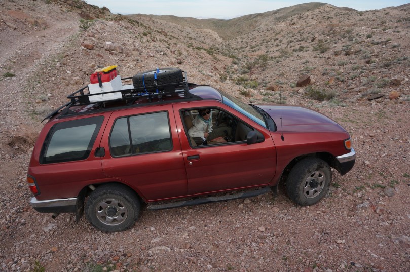
That’s Nancy driving. We make a good 4WD team.
We’ve been to so many of the park’s innumerable canyons, driven so many almost impassable roads, to places where there doesn’t appear to have been human activity since the mining boom, that I’ve taken to charting our ventures on a large D-size plot of the park topo map. It provides an easy visual to where we’ve been and where we still need to go. Because we need to go everywhere at least once.
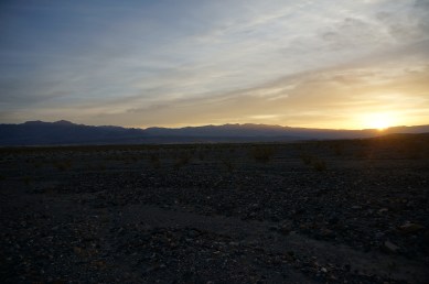
The typical day’s adventure would be rise before dawn, wander over to the motel’s early morning coffee service and then check out the sunrise over the Funeral and on the Cottonwood Mountains …

I can write a novel about our Death Valley adventures but let’s get back on track: Telescope Peak. That mountain in particular called to me. Most of the time I’d spent in the park had been at lower elevation or in the canyons with Telescope Peak pretty much lording over the place no matter where I was. So, I wanted to hike to the summit.
No problem, right? Well, for healthy people, it’s not. At least those with healthy knees. That leaves me out. My knees disintegrated when I was on the submarine but helped along considerably by two hikes to Kalalau Beach on Kauai. That’s a long hike – eleven miles one way – with a severe downhill at the end. Since those hikes, I’ve had trouble doing more than five miles before one or both knees break down, particularly on uneven terrain. The trail to Telescope Peak, which starts at a high-elevation camp site, is about fourteen miles round-trip and ascends 3,000 feet. In other words, well out of my range.
But, to paraphrase Henry Fonda in the great movie Midway, I wanted that summit. So, in the summer of 2010, a time of year when Nancy ordinarily would have nothing to do with Death Valley because of the ridiculous heat, we set off to conquer the top of the (local) world. Knees be damned.

We made the drive up to Mahogany Flats campground early in the morning, passing by the Charcoal Kilns, which are pretty cool themselves. The road past the kilns is one of the few in the park that actually gets closed by snow during winter. Mahogany Flats is a good place for dark sky viewing and we saw a couple of telescopes set up.


After gearing up, which included a ton of water each, we signed in on the register and headed up the trail. Water is key on this trail as it is on any in Death Valley. You don’t get the extreme heat experienced in the valley but high elevation hiking demands hydration, or you can suffer altitude sickness. It’s a thing even at this relatively modest elevation (we’re not climbing K2 here). Our plan was to cache water just before the switchbacks near the final ascent of the peak, which is a common thing to do on this trail.

Hiking Telescope Peak is much more than the destination. The views of the valley below are incredible as the trail winds along the east side of the range. When the trail shifts over to the west side, you get views of the White-Inyo Mountains with the Sierra Nevada beyond. You walk among wildflowers, pines, and most rewardingly – ancient bristlecone pines. I love these trees. Nearby (sort of), there’s a great expanse of bristlecone pines on the slopes of the White Mountains, including what was until recently considered the oldest tree on Earth (Methuselah, ~4800 yo). In 2013, an even older tree was discovered there with an age just over 5000 years. The trees along the trail to Telescope Peak are not nearly so ancient but they’re still cool and are probably older than any you’ve seen if you haven’t been to the White Mountains.


You can camp up here. The best, maybe only, spot is at Arcane Meadows, which is a wonderfully idyllic field about a third of the way along the trail in a saddle between the two peaks you hike around to get to Telescope (Rogers and Bennett peaks). It’s great place to stop and consider the majesty of where you are.

After coursing around the two minor peaks, we eventually found ourselves getting close enough to sense the summit. And by sense, I mean we could see Telescope Peak ahead of us. We began to gain elevation more quickly. My knees were holding up so far, but I knew I could make the summit easily enough. To get off the mountain, however, I might need a medi-vac.

The final bit of hiking is the most brutal as the trail gets steep and reverts to a seemingly endless string of switchbacks. It was here that that we cached our extra water – no point hauling that up to the top. As we switched back and forth, I really began to feel the elevation. I was getting winded easily and stopped often to let my heart stop racing. Nancy was not having any problems with elevation but had to stop for blister maintenance a couple of times. She hikes prepared, so had moleskin blister pads in her pack.
The switchbacks behind us, the final short piece to the top remained. Nancy, being a great hiking partner, knew that the peak was my goal, my challenge to conquer. A challenge that had seemed beyond my capabilities, but here we were. So she waved me ahead and took photos of me hiking up to the top, culminating in a Rocky-style celebration. Then she casually joined me, because, you know, it’s not like a difficult hike or anything.


We spent some time at the summit, which is a small area with a good sitting rock, taking in the views and taking photos. The weather was great all along the hike with pleasant temperatures (keeping in mind that the valley below was maybe 115, 120 degrees). As I mentioned, you can see Mt. Whitney from the top of Telescope Peak. It’s really cool to stand in one spot and see the highest point in the continental US and with a turn of the head, see the lowest. There’s a log book inside an ammunition can, so we recorded our accomplishment and read some of the other entries.


We had the summit to ourselves – this is a popular Death Valley hike but not so popular that you meet many people on the trail. At least we didn’t. And that’s the way it should be. When you accomplish one of your dreams, check off a major bucket list item, you need it to be the way you imagined. I imagined Nancy and I standing on top of the (local) world together, looking down on the park that has become an integral part of who we are. We are Death Valley hikers and we have been to the top of the mountain.
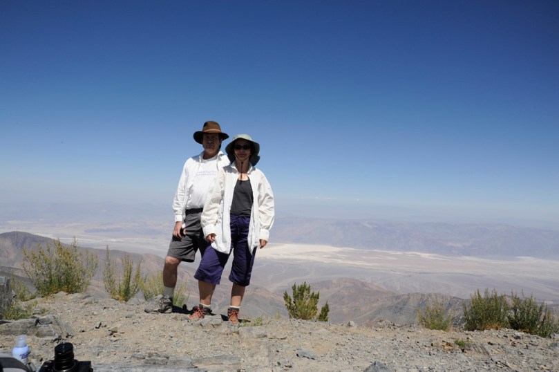
*You’ll notice we’re both wearing long-sleeve white shirts and wide-brim hats. These two apparel items are key to surviving to a ripe old age if you spend a lot of time in Death Valley.
Hiking back to the Pathfinder was painful. As predicted, my knees failed, both of them. The last few miles I took very slowly, sometimes even turning backwards to step down off a rock (it’s easier on the knees). In all, it took over twelve hours to hike fourteen miles with a three thousand foot ascent/descent, way longer than most people manage.
After Telescope Peak, my knees now get damaged more quickly and take longer to recover. Summiting that mountain has had lasting effects on my ability to hike.
I don’t regret it. You only live once.
